Sweers Island: changes over two hundred years since Flinders' visit
by P. Saenger
Centre for Coastal Management, Southern Cross University, Lismore, NSW 2480, psaenger at scu.edu.au
Saenger, P., 2005. Sweers Island: changes over two hundred years since
Flinders' visit. Gulf of Carpentaria Scientific Study Report, The Royal
Geographical Society of Queensland, Brisbane, Geography Monograph Series
10:11-22.
Thanks also to the Royal Geographical Society of Queensland
Aboriginal Land Tenure
Following the abandonment of the phosphate shipping project on Sweers Island in 1977, the boundaries of the Aboriginal Reserve on the Island were redefined to exclude previously surveyed areas of crown land and the air strip (Queensland Government Gazette 1989.2.2329). Two sections were established, the northern section comprising 775 ha, while the southern section was of 480 ha. These reserves, however, were repealed in 1994, when a deed of grant in trust was granted to the Kaiadilt Aboriginal Land Trust. In 1996 a native title claim by the Kaiadilt people, as part of four applicant groups, was lodged for the land and waters from the high water line on Bentinck and Sweers Island to ‘as far as the eye could see’, a claim recognised by the Federal Court to five nautical miles seaward (The Lardil Peoples v State of Queensland [2004] FCA 298).
A retrospective assessment
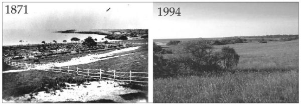
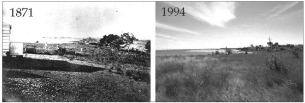
Judging from the early accounts of the vegetation, it seems probable that few changes have occurred and/or persisted, and that recovery from felling has occurred. Grass, herb and shrub cover has also apparently recovered from intense grazing by introduced stock (Figures 3 and 4, page 20), and the absence of macropod grazers has possibly facilitated this process. The flora of the island is diverse, and few weeds have been identified (Thomas & Pedley 2004). Few changes in the fauna appear likely; goannas and pythons remain common on the island, although one early report, apparently of abundant death adders, is intriguing as they have not been recorded since. Cane toads became established on the island between 1973–1990. Early accounts of an abundant avifauna still hold today and bustards remain common -

Figure 3: Identical views from one of the suburban blocks, looking north-west. Note the extensive use of Melaleuca saplings for fencing, the areas of overgrazed vegetation, and the large number of hides draped on the fence in the distance. (1871 photograph, Captain Sweet, courtesy of the John Oxley Library neg no. 67338; 1994 photograph, Brett Stubbs).

Figure 4. Identical views from the Customs House, looking north-east, over what George Phillips described in 1866 as 'open country'. (1871 photograph, Captain Sweet, courtesy of the John Oxley Library neg no. 67334; 1994 photograph, Brett Stubbs).
perhaps as a result of the non-introduction of rabbits, foxes, pigs or cats. In terms of the inshore marine environment, historical accounts of good fishing success still hold—presumably underpinned by the exten sive seagrass beds around the island, and the generally increasing mangrove areas. On the other hand, hard coral cover around the island appears to have declined over recent years, although no clear causes can be identified. Overall, the flora and fauna of Sweers Island has remained remarkably intact, despite a period when use and exploitation of the island’s resources was intensive.
Continued on Page 6 - Acknowledgements & References
Page I |
Page II |
Page III |
Page IV |
Page V |
Page VI

![]()


