

Historical Notes on Sweers Island
Peter Saenger
The use of Sweers Island by the Kaiadilt (Bentinck Islanders) is well documented. (1) As Tindale suggests, historical evidence indicates some occupation of Bentinck, Allens and Sweers Island with primary use focussed on Bentinck Island. The nomadic trips to Allens and Sweers Islands were largely dependent on whim, freshwater supply and specific hunting and gathering expeditions; all largely controlled by weather. These natives were basically gatherers of sea food and the wave platform areas and associated shorelands were likely utilized on Sweers Island. Women gathered 'tjilangind' (small rock oysters), 'kulpanda' (Arca mud cockles) and crabs during low tide periods while the men explored the wider littoral areas spearing fish, turtle, sharks and dugong. The Aboriginal fish-traps on Sweers Island (2) however, suggest a more sedentary use of the Island.
The aboriginal terms describing these places indicate that Bentinck Island was the "land of all" (Dulkawalnged) while Allens, Horseshoe and Sweers Islands were "men absent lands" (Dangkawaridulk). These primary indicators plus observations during visits by Flinders and Stokes and other visitors to the area including anthropologists Roth, Beazley and, more recently, Tindale, indicate that prehistorical use was sporadic and ecologically insignificant.
1580-1650:
Earliest exploration in northern
Australia and Indonesian waters by Dutch explorers associated with the
Dutch East India Company.
1606:
The first written record of
exploration in the Gulf of Carpentaria by Willem Jansz. In March and April,
he sailed down the west coast of Cape York, landing at Albatross Bay and
then continued as far as 14 deg S (Cape Keer-Weer) in the DUYFKEN. Jansz's
report was not encouraging. (3)
1623:
Jan Carstensz in command of
Dutch East India Company's vessels
PERA and ARNHEM took ships'
boats into the mouth of the Staaten River on 25th April. Carstensz named
the Gulf of Carpentaria after Pieter de Carpentier, Governor-General of
the Dutch East indies, 1622-28. He was to investigate the possibility of
trade with the natives and inquire for gold metals and find Torres Strait.
Carstensz failed to find Torres Strait and saw only 'naked savages' and
a few rivers. (4)
1644:
The first white man likely
to have seen Sweers Island in June or July 1644 was Abel Janzoon Tasman.
He had been sent by the Dutch Governor-General to determine whether a strait
existed between New Guinea and the 'Southland' (Australia) as shown on
Franco- Portuguese maps. (5) Tasman failed to find Torres Strait, probably
because he sailed too far offshore. (6) The dissatisfaction with Tasman's
voyage is best reflected in that a further exploratory expedition was sent
to the area with almost identical orders in 1756.(7) Although rebuked by
the directors of the Dutch East India Company for unremunerative exploration
- "Why bother about barren and remote countries inhabited by wild and unprofitable
savages?" (8) - Tasman's rank of commander was
confirmed and, in November 1644, he was appointed to the Council of Justice
in Batavia. (9) Tasman retired from the Company in 1651, becoming a wealthy
merchant until his death in 1659. (10)
The composite map of this journey is in the Mitchell Library and places a headland and a supposed river entrance ("The Maet Suyker") in the vicinity of what are now called the South Wellesley Islands; it seems clear that Tasman, who did not name the Island. (11) thought it part of a large promontory.
Pre 1800's:
Sporadic visits to the northern Australian coasts by Maccassarese- Buginese fishermen lost and/or seeking trepang and other marine biota did occur, although rarely were the Wellesley Islands included in these visits. (12)
Some evidence of these visits is attributed to the tamarind trees found on Fowler Island. (13)
1756:
Two ships, the RIJDER and BUIJS, under the command of Jean Etienne Gonzal were dispatched by the Dutch East India Company to "survey the coasts of the Gulf of Carpentaria, the north coast of Arnhem Land and to sail westwards ..." (14) These ships were separated by storms and failed to carry out their orders so that virtually no useful information resulted.
1802:
Nov. 16 - On his last voyage
in the INVESTIGATOR, Matthew Flinders sighted Sweers Island while exploring
the Gulfs southern coastline. He deduced that the opening west of the prominent
height of land (Inspection Hill) was the river entrance suggested on earlier
Dutch charts ('Maets Suyker's River'). According to Robert Brown (15)
the
botanist aboard the INVESTIGATOR "in the evening anchored under a low Island
about a mile from the shore & abreast of the only rising ground on
the Island".
Page 4
Nov. 17 & 18 Flinders anchored the INVESTIGATOR approximately two miles due south of Sweers Island in 4.5 fathoms. Taking a boat ashore he climbed Inspection Hill describing it as "a mass of calcareous rock, whose surface was cut and honey-combed".
Although the area had been called Maet Suyker's River on earlier Dutch charts (Tasman), Flinders renamed the island "Swears Island" after Cornelius Sweers, one of the Councillors of Batavia who had authorized Tasman's journey of 1644. He also named Inspection Hill from "its obvious nature as a vantage point".
Nov. 19 & 20 - INVESTIGATOR sailed west below Bentinck Island and north-west towards Allens Island. Boat parties went ashore for botanical observations on Allen and Horseshoe Islands. Flinders' party met Aboriginals on Horseshoe Island, exchanging caps, a hatchet and an adze for spears and woomeras. Flinders' observations as to the height, hair style, and physical features of the Aboriginals and the construction styles of their rafts, nets, beds and implements are most informative (16)
Flinders named Bentinck Island after Lord William Bentinck, former Governor of Madras: Aliens Island "after the practical miner of the expedition" and Horseshoe Island "from its form".
Nov. 21 - The INVESTIGATOR made its way back to the anchorage between Bentinck and Sweers Islands in order to facilitate further repairs (caulking). Flinders was quite impressed with this anchorage off "the west sandy point of Sweers Island". He wrote "though it may not be called a port, (the anchorage) is yet almost equally well sheltered, and I named it Investigator's Road".
Nov. 22 - The crew began repairs
on the INVESTIGATOR while Flinders took boat parties to Sweers Island to
take fixes from Inspection Hill and dig out a native well on the beach
not far from Inscription Point. Other boat crews were employed fishing
and exploring, finding the small freshwater lake on the south shore of
Bentinck Island. "During the crisis, the scientists had been busy on Bentinck's
and Sweers' Islands, They had found several new plants, noted the dominance
of eucalyptus, dwarf casuarinas, and pandanus in the tropical vegetation,
and observed many birds, including bustards, pelicans, gulls, 'sea-pies',
'ox-birds', and sand-larks." (17)
"During our stay at this anchorage I went several times on the islands & scarce ever without finding additional plants so that before we left it I had made out a Florule comprehending 190 species of perfect plants ..... The rise of the spring tides was found to be about 11 or 12 feet & a circumstance very remarkable was that while we remained the low of floods was commenced in the morning continued for 12 hours & the ebb during an equal time in the night. During our stay the ship was supplied with fish & the Island where we watered a Bustard was shot perhaps not essentially different from Chatrdiris, it weighed 12 1/2 lb & the flesh was well tasted that of the legs was much whiter than the breast ..." (18)
Collections of geological specimens were also made by Robert Brown and these were described by A.W. Fitton in 1827 as an appendix (19) to Captain Phillip Parker King's account of the voyages of the MERMAID and BATHURST, Fitton records that "In Sweers Island ..... a hill of about fifty or sixty feet in height was covered with a sandy calcareous stone, having the appearance of 'concretions rising irregularly about a foot above the general surface, without any distinct ramifications.' The specimens from this place have evidently the structure of stalactites, which seem to have been formed in sand "(20) In addition, "the shore, in various parts of the Island, was found to consist of red ferruginous matter, (bog-iron-ore?) sometimes unmixed, but not infrequently mingled with a sandy calcareous stone; and in some places rounded portions of the ferruginous matter were enveloped in a calcareous cement." (2)
Nov. 23-25 - A camp was established on Sweers Island under the control of Lt, Fowler. This group supplied fish and freshwater to the INVESTIGATOR Flinders received reports of extensive repairs required due to rotting timbers.
Nov. 26 - Flinders decided to complete the survey of the Gulf, hoping to be able to return to Sydney via the west and south coast in the winter or retreat to the East Indies if required.
Nov., 27 & 28 - Repairs and watering of the INVESTIGATOR were completed.
Nov. 29 & 30 - Flinders tried to sail out of Investigator Road against south easterly winds but experienced difficulty getting around Locust Rock so he anchored south of Sweers Island. During this anchorage, Flinders wrote an extensive summary of the fortnight spent in the vicinity of Sweers and Bentinck Islands: 'The stone most commonly seen on the shore is an iron-ore, in some places so strongly impregnated that I conceive it would be a great acquisition to a colony fixed on the neighbourhood. Above this is a concreted mass of coral, shells, coral sand and grains of iron ore .... The soil, even in the best parts, is far behind fertility; but the small trees and bushes which grow there, and the grass in some of the less covered places. save the larger islands from the reproach of being absolutely sterile. The principal woods are Eucalyptus and Casuarina, of a size too small in general, to be fit for other purposes than the fire: the Pandanus grows almost everywhere, but most abundantly in the sandy parts; and the botanists made out a long list of plants, several of which were quite new to them." [For example. Ferdinand Bauer prepared a beautiful illustration of Eucalyptus pruinosa, described from Sweers Island by Robert Brown.]
Flinders goes on to mention that turtles abound around the island as well as "indians". Flinders writes that "indians were repeatedly seen but they always avoided us and sometimes disappeared in a manner which seemed extraordinary. It is probable that they hid themselves in caves dug in the ground, for we discovered in one Instance a large hole containing two compartments, so to call them, in each of which a man might lie down. Fireplaces under the shade of the trees with dried grass spread around were often met with and these apprehended to be their fine-weather and the caves their foul- weather residences."
Flinders also introduces a mystery surrounding the island: "On Sweers Island seven human skulls and many bones were found lying together near three extinguished fires, and a square piece of timber, seven feet long which was of teak wood, and according to the judgement of the carpenter had been a quarter deck carling of a ship, was thrown up on a western beach. On Bentinck Island, I saw the stumps of at least twenty trees which had been felled with an axe or some sharp instrument of iron, and not far from the same place were scattered the remains of a broken earthen jar. Putting these circumstances together it seemed probable that some ship from the East Indies had been wrecked here two or three years back and part of the crew had been killed by the indians and that others had gone away, perhaps to the mainland upon rafts constructed upon the manner of the natives."
Dec. 1 - The lNVESTIGATOR sailed south from Sweers Island to an anchorage south-west of Sydney Island on the south side of Mornington island.
July 7 & 8 - Sweers Island and the Albert-Flinders Rivers region of the Gulf coastline were visited by Stokes in the famous BEAGLE on her third voyage in Australian waters. Stokes, who had been mate during the BEAGLE's world voyage with Charles Darwin in 1831-36, was charting the shores of Australia not investigated by Flinders or King.
The BEAGLE sailed into Investigator Road from Cape Van Diemens area. Twelve Aboriginals were observed "under Mount Inspection, a hill 105 feet high, and a most remarkable feature hereabouts, on the S.E. extreme of Sweers Island" (22) but Stokes was unable to make contact with them on landing.
"Sweers Island appeared to be very woody, and bounded by low dark cliffs on the north-east side. We found a long extent of foul ground, with a dry reef near its outer end, extending off two miles in a S. 330 E. direction from the S.E. extreme ..... A party was immediately dispatched in search of the INVESTIGATOR's well. (23) Stokes also recorded the cloud of locusts which enveloped Sweers but which later moved to Bentinck Island.
Fowler Island was named after
Flinders' lieutenant and "the INVESTIGATOR's old well was discovered half
a mile eastwards of the point to which I gave the name of Point Inscription
(24) from a very interesting discovery we made of the name of Flinders'
ship cut on a tree near the well and still perfectly legible although nearly
forty years old .... On the opposite side of the trunk the
name and the date of our visit
were cut".
(25)
In his log, Stokes summarized
his feeling on finding this reminder of Flinders: "It was thus our good
fortune to find at last some traces of the INVESTIGATOR's voyage, which
at once invested the place with all the charms of association,
and gave it an interest in our eyes that words can ill express .... I forthwith
determined accordingly that the first river we discovered in the Gulf should
be named the Flinders..." (26)
This tree (Celtis paniculata) was photographed in 1871 by Captain Sweet of the GULNARE while enroute
from Adelaide for cable laying at Port Darwin. After being blown down during
a cyclone in 1887, the tree stump was procured by the Queensland Museum
via Captain J.W. Jones, "the Gulf Pilot, and forwarded to the Portmaster
at Brisbane as Government property" (27) The tree arrived at the Museum
on 13/2/1889, officially "donated by the Port Office" and has been on display
since 1964. It is now located in the Surveying Museum of the SunMap Centre
in Brisbane.
Inscriptions visible (28) in 1887 include the following:
Lowy 1781
INVESTIGATOR 1802 Flinders' ship
INVESTIGATOR
Robert Devine (32)
BEAGLE 1841
Chimmo
N.A.E. Nov. 20th 1856
Karl Teats 1856
The Expedition 1861
J. Martin 1861
L.H.S. 1861
Austin 1861
?
W. Landsborough 1866
A.H.T. 1866
?
D. Clouston 1866 ?
W.J. Hay ?
W.C.A. Miles
W.S. Howell
W.Solby
According to Palmer the
following inscriptions are also present:
1798
Stokes
Norman
Whether Palmer actually
saw the tree is not known; however the inscriptions of' 'Stokes' and 'Norman'
are not mentioned by anyone else, nor are they still visible on the tree.
The Chinese characters are more puzzling and have led to various suggestions
of early Chinese navigators in this region. However, it seems likely that
the 'Chinese' characters are one of the macassan scripts used by the early
trepangers. Presumably Palmer's claim is the basis for those of 'G.P'.
(38) and Reed (39), although 'G.P.' claims that "Flinders found evidence
of the visit of Chinese to Sweer's Island. He found a tree on which were
carved some Chinese characters, and the date, 1798 ....... Flinders carved
the date and name of his ship on the same gnarled old tree on which he
found the Chinese characters." (40) However,
no mention of Chinese or Macassan characters, nor of a 1798 date, is made
in Flinders' account of the visit to the Island.
Walter E. Roth, the Northern Protector of Aborigines, makes the following observations (41) regarding the remains of the tree during his visit to Sweers island in 1901. "... the limb bearing the actual inscription was removed some years back .... What remains of this very interesting historical landmark has been mutilated by subsequent visitors, and of the fence which once surrounded it, only a corner post now remains. So as to identify it for the future, I purposely took note of the more legible incisions. On the eastern aspect of the butt appears EXPEDITION and 1861, while above it is J. SWAN: along the western side is to be seen P. W. ARMSTRONG Dec 1885: upon the main branch is BN written within a square border."
Stokes describes finding a
new water supply closer to Point Inscription: "Being desirous of ascertaining
if now, in the dry season, water could be obtained in other parts of the
island, I ordered a well to be dug on the extreme of Point Inscription,
a more convenient spot for watering a ship, and at a depth of 25 feet met
excellent water, pouring through a rock of concreted sand, pebbles, and
shells.
Our success may be attributed,
as Flinders says, to the clayey consistence of the stratum immediately
under the sand, and to the gravely rock upon which the stratum rests; the
one preventing the evaporation of the rains, and the other obstructing
their further infiltration .
This was a very important discovery, as investigator Road is the only anchorage for vessels of all sizes at the head of the Gulf in either monsoon, and possesses an equal supply of wood, fish, and birds, with turtles close at hand on Bountiful Islands. Moreover, should an expedition be formed for the purpose of exploring the interior from the head of the Gulf, it is, as Flinders remarks, "particularly well adapted for a ship during the absence of the travellers." In addition to this, it is a point at which an expedition would first arrive to arrange plans for the future; and lastly, I should observe that in case of our being fortunate enough to find rivers or fertile country on the southern shores of the Gulf, we at once saw that we might look forward to the time when Investigator Road should be the port from which all the produce of the neighbouring parts of the continent must be shipped, and when it should bear on its shores the habitations of civilized man, and the heaven-ward pointing spires of the Christian Church ....... On duly weighing these considerations in my mind I determined to make an accurate survey of this anchorage, including Sweers and the eastern portion of Bentinck Island; and to dispatch two boats to examine the group of islands to the north- west, and the main land from thence to abreast of the south-west end of Bentinck Island. On the morning of the 9th, accordingly. Messr. Forsyth and Parker proceeded with the whale boats on this service." (42)
Stokes also reports that "near Point Inscription, I found a native skull on the shore ...... they must have been exposed some time, as they were very nearly destroyed by the action of air. How they could have come in this situation was a mystery, as there was nothing indicating a place of burial." (43)
From Mount Inspection, "the north-eastern end of the Island, also, could be seen, fronted with rocky ledges extending three quarters of a mile off. This hill is a mass of calcareous rock, similar to the high parts of Bountiful Island, with the same honeycombed surface, as if it had been exposed to the action of the sea. In other parts of the island there is a great quantity of ironstone; and the cliffs on the eastern side are mixed with this and pipe-clay; on the northern extreme are some lakes and swamps.
The soil is chiefly a mixture of sand and decomposed vegetable matter; but it cannot boast of fertility. The wood on the island, which consisted for the most part of gums, wattles, a few acacias, palms, and, near the beach, a straggling casuarina or two, bespoke this by its stunted appearance; but as cotton grows well at Port Essington, there can be little doubt that it will thrive here. Several of the bustards spoken of by Flinders, were noticed; but too wary to be killed. They were as large as those seen in the neighbourhood of Port Phillip, but much browner. The other birds, most common, will be found in an extract from the game book, given in a future page. We saw no animals, except some large iguanas." (44)
The extract from the game book
(45) gives the following details: "Sweers Island (July), 151 quails,
87 doves, 20 pigeons, 3 pheasants, 8 white and 2 black cockatoos, 5 spur-wing
plovers"
Page 13
July 9 - 13
Forsyth and Parker charted
much of the Wellesley Island Group and nearby shoreline, landing at Bayley
Point. Point Barker, Allens and Forsyth Islands from the ship's boats.
July 14-24
BEAGLE took soundings and
recorded data between Sweers Island and the Gulf coast, departing Sweers
Island on 21 July.
July 29
Stokes fulfilled this undertaking
while in an inlet where he "was delighted to find our progress rendered
hazardous by sunken trees". This river he named the Flinders,
Stokes discovered another river further east. He travelled up this stream about 50 miles searching for fresh water. He called this river the Albert, after the Queen's consort, He also named the nearby alluvial lands the "plains of promise" after a day's land exploration on August 4 at the terminus of his boats progress upriver.
Aug. 7-18
Numerous other inlets and bays along the coastline were charted prior to sailing for Port Essington.
May 12 - The North Australia Expedition under A.C. Gregory departs Brisbane for the Victoria River in the schooner TOM TOUGH (Captain Gourlay) and barque MONARCH. The MONARCH is holed near Melville Island and after delivering supplies, sails for Singapore. The TOM TOUGH is holed in the Victoria River.
1856:
June - In Sydney, there had
been apprehension concerning the safety of the the NAE and the British
Government had dispatched Lieutenant W. Chimmo, RN., to Sydney whence he
was "... sent to render assistance to the above expedition by his Excellency,
the Governor General of New South Wales". (46)
The
paddle steamer TORCH (owned by Mr. Watson) was chartered, loaded with 130
tons of coal and Lt. Chimmo sailed north from Newcastle on 24 June to gain
news of the explorers.
Meanwhile, Gregory and a small party had left overland on June 21, 1856, arriving at the Albert River on 30 August.

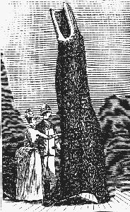
Investigator Tree, Sweers Island
July - After makeshift repairs to the TOM TOUGH, the schooner departs for Coepang, Timor on 17 July 1856. As more intricate repairs were required, the TOM TOUGH departs for Sourabaja on August 9. At Sourabaja, the TOM TOUGH's mast was found to be fractured and as the time required to repair this was too long, Thomas Baines, the artist and storekeeper for Gregory's party, discharged the TOM TOUGH and hired the brigantine MESSENGER a slower but more robust vessel under the command of Captain Devine, Thus, the MESSENGER was dispatched to fill the role previously allotted to TOM TOUGH,
July 30 - The TORCH arrives
off Sweers Island in the evening and immediately a party is sent ashore
to find water. "On landing we found that natives had preceded us, their
tracks were plainly visible, and they had left a bundle of wood for fire
or signals on the spit: they had taken a canoe with them into the wood,
and had evidently come from Bentinck Island. It was too dark even to find
the well, so I had to return on board ..." (47)
July 31 - Before dawn "... all hands were on shore looking for water. About a mile East of our anchorage we found what remained of the INVESTIGATOR's well, completely blocked up, to be distinguished only by a slight undulation in the ground: traces of natives were seen under almost every tree. Sticks for erecting tents or huts were lying about, tied up with grass-cord, and bundles of sticks ready for burning. It was not long before we all assembled beneath THE TREE (48) (Chimmo's emphasis), which still plainly bore the inscriptions of the 'INVESTIGATOR and BEAGLE;' the former fifty- four years since, the latter fifteen: and here we indulged in a glass of the 'Queen's own.' .... The TORCH's name was not added, (49) for if all did the same the original would soon be obliterated, which I hold to be next to sacriligious, considering that the original and originator stand alone as long as wind and weather permit." (50)
"The remains of the BEAGLE's well was found, but full of earth, stones, and wood .... Our hearts sunk within us as we gazed on this piece of destruction, and also at the prospect of finding no water. However... tools were brought from the ship ... and every one went to work to clear the well. By noon this was done, and the water was dripping into it through a rock of concreted lime, sand, shells, and pebbles .... By afternoon we had completed water (although somewhat brackish) to about five tons; and in return deposited pumpkin seeds and Indian corn round the well, where the soil was rich; cut our vessel's name on a log of wood across the well, and bade it adieu ..." (51)
On returning to the anchorage from the assembly underneath the INVESTIGATOR tree, a "... piece of a lower deck mess plate, (China.) as well as a metal inkstand of European manufacture with the lid gone ..." (52) were found and Chimmo puzzled over how these remains came to be there. On the western side of the Island, the remains of a Malay proa with beams of teak were found at high water mark. 'We concluded she had been cast away during the N.W. monsoon; her beam was 17 feet; length could not be ascertained." (53)
Aug. 1 - The TORCH departed Sweers Island and headed for the Albert River mouth "watched by the natives who were on Bentinck Island, gazing at us with astonishment to see a vessel move through the water by 'smoke.' To this we attributed their shyness." (54)
Aug. 2 - When he entered the Albert River he sent two boat crews upstream to the rendezvous, and for a whole evening they amused themselves inscribing names on trees. Chimmo said that they also hung from trees bottles containing notes for Gregory. "Lieutenant Chimmo then sailed to the Victoria River, and at the base camp he found in an oven a note from Thomas Baines informing the finder that Gregory had left for the Albert." (55)
Aug. 31 - On approaching the Albert River, Gregory's party found a number of marked trees "consisting of several names of seamen, who appeared to have formed the crew of a boat sent up the river by H.M. steamer TORCH" (56) four weeks earlier. Gregory concluded that the visit of the TORCH had no connection with his expedition.
Sept., 3 - When the TOM TOUGH failed to rendezvous with them at the Albert River, Gregory left instructions for the schooner, departing overland for Brisbane.
Oct. 23 - MESSENGER's longboat was launched in order to expedite the trip to the Albert River. The MESSENGER, in contrary winds, was achieving less than a knot, (57) and Baines felt that with the long delay, Gregory and his party might start for Brisbane with insufficient supplies. The longboat was manned by Messrs. Baines, Phipps and Graham. (58)
Nov. 10 - The brigantine MESSENGER anchors off Sweers Island about 11pm. (59)
Nov. 11 - 'The boat ashore this morning before breakfast & got a letter from Commander Chimmo in command of the New South Wales War Steamer the TORCH found it a few feet from the BEAGLES Well. There appears to be plenty of water in the well ... water is not fit to drink, as it is ctd, Salt and bitter as well .., but we must have water from somewhere we take them aboard and then sail for the Albert." (60) The MESSENGER reaches the Albert River and the crew finds the letters left by Gregory, advising that the expedition had left overland.
Nov. 17 - Baines arrives off the Albert River with the longboat to find that the MESSENGER had arrived before him. After consultation with Captain Devine and against Gregory's instructions. it is decided that the MESSENGER would return to Brisbane via Timer and the west coast. But first. the water supply on the brigantine needed to be replenished and consequently the MESSENGER sailed for Sweers Island.
Nov. 18 - "... anchored off Sweers Island ... about 10 am. Expedition men all ordered where to dig out Flinders Well that we do and get good water aboard at night." (61) Thomas Baines had "organised a party that took every available beaker and bucket to a well on Sweers Island, filled them with fresh water, and brought them back in the longboat to MESSENGER where Devine supervised the replenishing of her empty casks", (62) an operation that took two days.
Nov. 19 - "During the day nearly all the men had carved their names on some smaller trunks of the INVESTIGATOR'S tree and one invading the main stem had made some unintelligible cuts two or three of which came across the name of the INVESTIGATOR I gave orders that this relic of the Adventurous old Navigator should be respected and as it was now barely legible I cut the word afresh just below it. The Captain cut his own and vessels name and I carved the Expedition Mark and date. (63)
Braddon (64) shows the Thomas Baines sketch of the inscribed tree with the following legend: 'A tree near Flinder's Well on Sweers Island with the names of INVESTIGATOR and BEAGLE carved on it. The uppermost is the original name carved by Flinder's crew. The lower and more distinct was cut by Baines to mark the spot visited by the old navigator when his own might be effaced.
Nov. 20 - Inscription left on Sweers Island tree by MESSENGER crew members: 'N.A.E. 20th Nov. 1856'. Also inscribed is 'Karl Teats 1856'.
Nov. 23 - "... land on the shore three quarters of a mile north of them [the wells] under a Cliff which seemed to be composed of a material similar to pipe clay with reddish veins. Captain Devine and I walked some miles to the North passing over plains with silverleafed iron bark. Eucalyptus and a long but shallow gully filled with green grass moist soil and clumps of pandanus but we could find no water though we saw several cockatoos.
We returned along the beach ... We picked up a plank carved with rosettes and other devices .., Also the bowsprit of a Chinese junk, a square balk 6 inches thick with carved work on its lower side and ornamental cap.
We kept the long boat going between the vessel and the shore with heavy loads of wood all day." (65)
"One of our largest water casks being gnawed through by rats, 400 gallons of water were lost. This rendered it necessary to shoot the horses and throw them overboard. They could not have been landed at the Albert .., and on Sweers there was no surface water for them to drink. Beside this, as there were no mares, no good purpose could have been answered. I had a pair of goats which I intended to leave, but the female unfortunately died. I planted cocoa-nuts in a variety of places on Sweers Island." (66) Whether the lone surviving goat was actually left on the island is not clear from this account.
1861:
Aug. 24 - The Victorian Colonial Warship VICTORIA and the FIREFLY (188 tons built in 1843) depart Brisbane for the Gulf of Carpentaria carrying the William Landsborough search party (67) for the overdue Burke and Wills Expedition and to convey supplies for the search party led by Fred Walker which was leaving overland from Rockhampton on the 25th. August 1861.
Sept. 27 - The VICTORIA and FIREFLY anchor off Bountiful Island to catch turtle to make up for the provisions lost when the FIREFLY ran aground in the Sir Charles Hardy's Islands, "Eight were put on board in less than three hours and twelve more were turned over on their backs on shore. That night the grass was set alight to assist in catching turtles. In two days 126 turtles were caught weighing between 150 and 200 lbs." (68)
Sept. 29 - According to Diedrich Henne, Baron von Mueller's 26- year-old botanical assistant attached to the search party, the VICTORIA (Captain W.H. Norman) arrived at Investigator Road with the FIREFLY (Captain T. Kirby) In tow. "Our two transports the NATIVE LASS and the GRATIA with coal etc, had already arrived before us" (69) In his narrative of the voyage, Captain Kirby refers to the brig GRECLAN and the schooner NATIVE LASS (Master A Paton) as having been chartered by the Victorian Government to "convey coals and stores for the use of the Government Steamer" (70)
"A land base for VICTORIA was formed on Sweers Island - a shed for stores and tents for one officer and three men, As coals were landed a party was employed cutting grass for the horses and another employed on building a turtle pond. It consisted of a stone wall 20 feet below low water mark to high water mark; many turtles died before the pond was completed." (71)
Sep. 30 - "... This morning I accompanied Captain Norman and Dr. Patterson ashore to Sweers Island. On it we found fine young grass not above a few months old .... The island is of sandstone formation and the land is very sandy. The grasses on it are good. It is lightly timbered with the pandanus palm, oak trees (casuarina), stunted white gum, black flgs, red plum and other trees. The fruit on the plum and fig trees. especially the former, are very nice ..." (72)
"Mr. Campbell and self landed
on Sweer's Island to cut grass for the horses; took our guns; grass plentiful.
Saw many birds - such as bustards, pigeons, quail, pheasants, crows, native
companions, etc. No surface water was found, but
the dews at night are very heavy, more like rain than dew." (73)
In the afternoon, Landsborough and Captain Norman also inspected SWEERS ISLAND the Island. Captain Norman reports: "Found the old tree with their ship's name cut on it, looking quite healthy". (74) "MESSENGER is marked on another tree ....".(75)
Landsborough describes Sweers Island as follows: "Bentinck Island is about thirty miles in circumference: Sweer's, only three: both are well grassed and wooded ...... In the afternoon Captain Norman and I landed on Sweer's Island to reconnoitre, and more especially to discover the well, sunk there by Flinders. We found the wells, but they were choked with sand. We also came upon a tree on which INVESTIGATOR was carved, and the word was still quite legible, though cut so far back as 1802, probably by the hand of the unfortunate Flinders. Captain Norman determined to repair the wells, and to form near them a depot for his superfluous ship's stores. We then selected a place on the beach within the tidal line, for forming an enclosure for the turtles. Further inland we found the grass of good quality, and fit for cutting, a discovery which pleases us both, as the sheep we had on board could now have the advantage of grazing, and my horses that of fresh fodder, in which we were running short. For all practical purposes, Sweer's was preferable to Bentinck Island: on the simple ground that the latter was inhabited by hostile blacks, while the former is only visited by them at distant intervals. Their means of transit consists, not of canoes, but of rude rafts formed from logs tied together with strings of plaited bark." (76)
Continued on Page 2.
Title Page | Page I | Page II | Page III | Annotations

|

|
home | sitemap | aviation topics
Copyright © 1997-2026 dropbears ![]()